Wagon trails such as Old Quarry Road and Hendricks Canyon Trail were constructed by frequent use over time, compacting soil into defined ruts, and not by mechanical means. The History of Emigration Canyon provides a logical explanation for the existence of such well used roads on land in the public domain before any private rights existed. The History of Emigration Canyon, 2nd Edition, chapter on The Emigration Canyon Railroad begins with a discussion on Le Grand Young and the Salt Lake Rock Company quarries in Emigration Canyon.

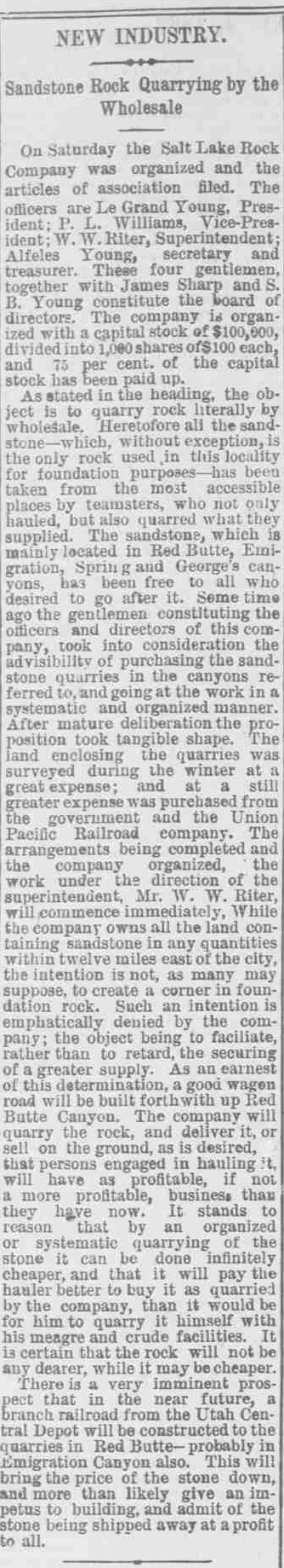
In the early years, rock and building materials were free for the taking, which prompted a large business for teamsters. The teamsters were reported to be a rough bunch of men. They not only hauled the rock but also quarried it themselves. By 1881 the demand for sandstone for building foundations was reportedly outstripping the supply, and rock quarries appeared to be a good investment. LeGrand Young purchased over fifteen hundred acres of sandstone and limestone–producing land in Red Butte, Emigration, Spring, and George’s Canyons from his uncle John W. Young, Brigham Young’s son, and the Union Pacific Railroad. Another deposit of Nugget sandstone was discovered high in Emigration Canyon, so Young expanded his holdings into the upper part of that canyon. The quarries were surveyed at “great expense,” and the Salt Lake Rock Company was incorporated in June, 1882, with LeGrand Young as president. Other members of the Board of Directors were P. L. Williams, W. W. Riter, James Sharp, and S. B. Young. The total capital stock was $100,000, and the intent of the company was to quarry rock wholesale.
This new business was not met with pleasure by the teamsters, since they could no longer quarry the rock free of charge. They accused the Salt Lake Rock Company (which now owned all of the land containing sandstone in any quantity within twelve miles of the city) of trying to corner the lucrative market on foundation stone. The company emphatically denied this claim, stating that it intended to facilitate, rather than retard, the securing of a greater supply of this important building material. To demonstrate its earnest intent, Salt Lake Rock promised to build a good wagon road up Red Butte Canyon, and it appears that the company also extended a wagon road to the Emigration Canyon quarries in Pinecrest and Brigham Fork. The Quarry Road left the main canyon road at Sharp’s Hollow, later called Pioneer Fork. It followed the natural contours of the land along the northern bench of the canyon until it reached Brigham Fork. After the quarries were abandoned, sheepmen, four-wheel drive enthusiasts, and hikers still used the road as backcountry access. Most of the old Quarry Road was buried beneath the Emigration Oaks subdivision, though short remnants are still visible there. The road up Brigham Fork is becoming overgrown, but it remains.
After building this road, the company found that teamsters were using it to steal stone, so they closed it, reserving it exclusively for the company, very much to the aggravation of the teamsters who had once again become accustomed to taking stone for free. Salt Lake Rock quarried stone in a systematic fashion, apparently blasting down large chunks with dynamite and breaking these into smaller stones for transportation and building. This stone was then sold to teamsters on the ground or transported to the city by the company. Rock quarrying in nearby Red Butte Canyon was an extensive affair. At its peak, thirty-five men lived in that canyon and worked exclusively at quarrying rock. Stonemason Charles Lambert, who had worked on the Mormon Church’s Nauvoo Temple, carved gravestones in Salt Lake City from the 1850s to the 1860s. He preferred the reddish sandstone from the quarries in “Redbute and Killion’s Kanyon.”
In a Salt Lake Daily Herald article dated June 4, 1882, (source|image) the Salt Lake Rock Company announced acquiring land in Emigration and surrounding canyons previously worked by the public. One such citizen who previously worked for some years on the quarries in Emigration Canyon was William Bowman, considered one of the most experienced quarrymen in the country. Bowman resided in the 11th Ward with his wife, Margaret, and seven children when he committed suicide because he had been “greatly exercised over the loss of the quarries in which he had worked for many years, and which had been swallowed up in the claims of the Salt Lake Rock Company… which he considered he had been robbed of.”[1]
The article was an offer of public road access for teamsters to purchase quarried stone ‘on the ground’ and haul it for a profit. The roads in Emigration Canyon existed prior to this announcement and were noted as ‘road to stone quarry’ in the survey notes of Ferdinand Dickert on December 13, 1881. Le Grand Young would not have had authority to close any of the roads in Emigration Canyon until at least 1900 when he first took title to the disputed properties of Lloyd G Johns. If there was any attempt to close a road, it was likely restricted to the portion of road over LeGrand Young’s property in Red Butte and after May 1895 when LeGrand Young filed for a temporary restraining order against Peter Hanson for unlawfully taking $700 of stone from the Red Butte canyon quarries. This could also refer to the permanent road closures in Red Butte of the upper road in 1887 and the remainder of the road in a 1906 Act of Congress.
By 1895 the rock quarrying in Red Butte Canyon was polluting Red Butte Creek, the only water supply for Fort Douglas on the dry east bench. The government closed the railroad line and quarries there, and LeGrand Young was forced to exchange his quarries in Red Butte Canyon for just compensation. The compensation he received included the right-of-way across the western portion of the fort along what is now the portion of Wasatch Drive between the University of Utah lower campus and the Health Sciences Center, the right-of-way up Sunnyside Avenue, $30,000 cash, and the land in the Federal Heights area.
There were two acts passed by the US Congress involving land exchanges with LeGrand Young. The first act closed the quarries and railroad in Red Butte with the Act of Congress Chapter 341 titled, “An act granting a right of way through certain public lands of the United States in the Territory of Utah, and for other purposes.” passed Mar. 3,1887. The later Act of Congress, Senate Bill S6396 of 1906 granted 42.3 acres known as Popperton Place to Le Grand Young in exchange for nearly 1,000 acres along the lower ridgeline between Red Butte and Emigration Canyon including “all of lots 4, 5, and 6, of section 2, Township 1 South, Range 1 East, and all of section 36, township 1 north, range 1 east, Salt Lake meridian” as well as a release of all rights reserved by the previous act. This exchange was supported by the press, except for the closing of the last quarry in Red Butte, and the land soon sold to a private developer.
The Emigration Canyon quarries, significantly smaller and further from town than the Red Butte quarries, were now Young’s only source of rock. There were a red sandstone quarry in Burr Fork in today’s Pinecrest and two quarries in Brigham Fork, a small one for red sandstone and the other for white/yellow. Smaller deposits of sandstone in Killyon and Gold Gulch were not commercially exploited. Rock from the white sandstone quarry was particularly desirable because of its strength and color. It was used to build the foundation for the wall around Temple Square.
Salt Lake Rock Company Mining on the Subject Property

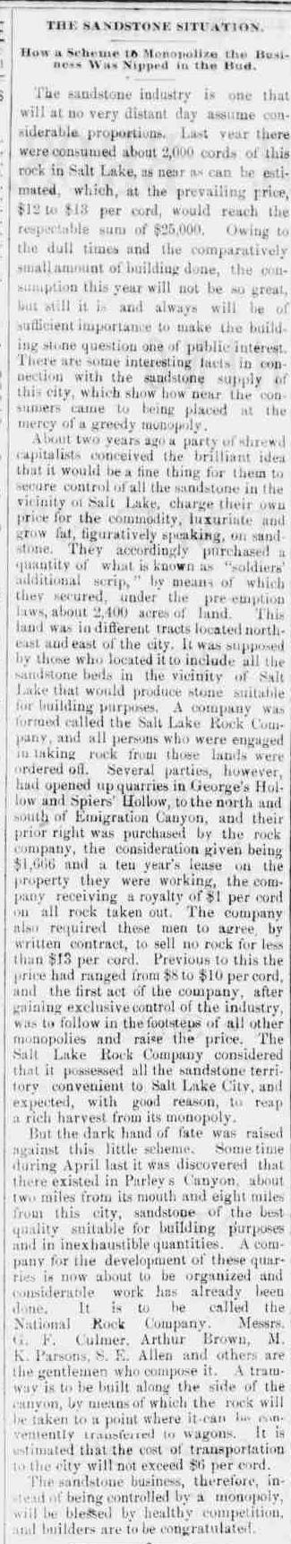
An October 1884 article in the Salt Lake Evening Chronicle accused Salt Lake Rock Company of conspiring to monopolize the 2,000 cords of sandstone consumed the previous year in Salt Lake, estimated to be worth $25,000 at the prevailing price of $12 to $13 per cord.[2] The article explained 2,400 acres containing “all sandstone beds in the vicinity of Salt Lake that would produce stone suitable for building purposes” were purchased through “soldier’s additional scripts.”
On May 31, 1882, a month before the Salt Lake Rock Company incorporated, Lloyd G. Johns paid the $11 filing fee for his second homestead claim of 80 acres authorized by the Soldier’s Additional Homestead Entry under Section 2306 granting additional homestead lands to soldiers and sailors who served in the war of the Rebellion. This act allowed veterans six months to begin his settlement and improvements while reducing the five year proving up period required to perfect title by the number of years served in the war, provided “that no patent shall issue to any homestead settler who has not resided upon, improved, and cultivated his said homestead for a period of at least one year after he shall commence his improvements as aforesaid.”[3]
Mr. Johns filed Homestead Application 1888 for two 40-acre parcels: one NE1/4 of the SW1/4 of Section 22, east of what is today known as Pinecrest and the Subject Property in the SE1/4 of the SE1/4 of Section 20 in Hendricks Canyon at the head of Freeze Creek. There is little evidence in the public record to explain why Johns claimed two remote parcels not suitable for farming separated by miles of rough terrain as the first two patented homestead claims in all of the township. The most logical explanation is that Johns aimed to capitalize on existing rock quarries and wagon roads developed by teamsters on what was public lands at the time.
This motive is what presumably led Johns and others to deed parcels in Emigration, Red Butte, and Spring Canyons to the Salt Lake Rock Company dated July 29, 1882.[4] This date is only a month after incorporation by Le Grand Young and less than two months after Johns filed the homestead application. On the same day, Seymour and Le Grand Young recorded a deed granting Salt Lake Rock Company the remaining Emigration Canyon quarries in Brigham Fork and in Pinecrest Canyon adjoining John’s 40-acre parcel in Section 22.[5]
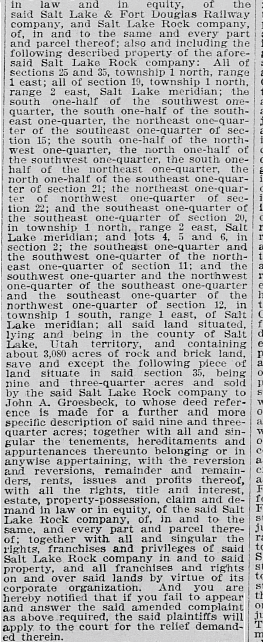
These properties accounted for all of Salt Lake Rock Company’s Emigration Canyon quarries[6] located in three adjoining draws on the north side of Emigration Canyon: Burr’s Fork (Pinecrest), Brigham Fork, and Freeze Creek (Hendrick’s Canyon). However, the transactions for all the property in Emigration Canyon were invalid at the time. A homestead patent for the two 40-acre parcels was not issued to Johns by the United States of America until 1888. The transaction granting the Brigham Fork property from the Union Pacific Rail Road was also well before the United States of America deeded the property to the railroad in 1897.[7] Young eventually succeeded in acquiring clear title to the Subject Property in 1903,[8] with a deed issued for the subject property April 7, 1906 following a series of tax sales in the 1890’s and 1900’s.
This did not prevent Salt Lake Rock Company from commercializing quarries on the Emigration Canyon properties. Salt Lake Rock Company manager Robert Miller advertised between March 23 – 25, 1888 for “four good quarrymen and six teams, to quarry and haul rock from Red Butte and Emigration Canyon Quarries.”[9] Advertisements in 1888[10] promoting red and white sandstone from quarries in Emigration and again in 1890[11] indicates the quarries remained some of the few commercial quarries providing building stone to Salt Lake through 1900.[12]
Old Quarry Road was the only route to access Salt Lake Rock Company’s white sandstone quarry in Brigham Fork and Hendricks Canyon Trail that provided access to the Hendricks Canyon quarry while connecting the two across Section 28. The stone was difficult and expensive to access over these wagon roads which was used in “the famous old lion, an historic object of interest occupying a prominent position in the Lion House [for sixty years] constructed at 63 East South Temple Street, Salt Lake City in 1855[13] and foundations for the residences of Thomas Weir,[14] the O.J. Salisbury,[15] and the Woods on Brigham Street around the turn of the 20th century.[16]
Old Quarry Road remained the only access to Brigham Fork until a wagon road from Pinecrest appears on the 1908 Browne and Brooks map. This is around the time Le Grand Young began grading a route up Pinecrest and into Brigham Fork in 1907[17] for his railroad which began service in July 1908.[18] The rock quarries were worked extensively with rock hauled by team over the roads prior to the railroad[19] and teams were expected to continue hauling rock after the railroad.[20] Young leased these quarries in September 1908,[21] which he later incorporated into the Emigration Canyon Rock Company in 1910.[22] The quarries continued operations[23] until the railroad was abandoned in 1917 “owing to small demand for rock building purposes” with the advent of cement.[24]
Mining in Hendricks Canyon
Mining was also active around the Subject Property, in an area referred to as Hendricks Canyon on unpatented mining claims,[25] between 1894 and 1910. At least nine notice of locations[26] to mining claims were filed with the Salt Lake County Recorder in the SE1/4 of Section 20 that were only accessible by the Right-of-Way.
January 8th, 1894, the “Hendricks Canyon Rock Quarry placer claim of gold, silver and other precious metals” was recorded by the Hendricks Canyon Rock Quarry Association as “situated in a fork of Emigration Canyon about one mile and a half up Hendricks Canyon being the SE 1/4 of Section 20 T1N R2E”.[27]
June 6, 1900, Claude B Durst, et al., filed a Notice of Location for the Duquesne Rock Quarry on the SW1/4 of the SE1/4, the NW1/4 of the SE1/4, and the NE1/4 of the SE1/4 of Section 20 T.1N. R.2E. in the Hot Spring Mining District on May 31, 1900.[28] ”This claim is located upon a valuable vein or deposit, bearing gold and other precious metals, situated in Hendrex [sic] Canyon.”
Claude B Durst, et al. later filed a second Notice of Location for the Durst Rock Quarry Placer Mining Claim on the NE1/4 of NW1/4 and SW1/4 of SE1/4 of Section 20 T.1N. R.2E. in Hot Springs Mining District dated April 16, 1903.[29] “This claim is located upon a valuable vein or deposit, bearing gold and other precious metals, situated in Hendricks Canyon.”
E.L. Land, et al. filed a Notice of Location for the Lone Tree Lode and Lone Tree No. 1 Lode on Section 20 in Hot Springs Mining District, dated February 10, 1905.[30] The Lone Tree Lode claims describe, “This claim is located on ridge between South Fork of Red Butte Canyon & Hendricks Canyon, the latter passes between Sand Stone Peak & Pear Peak & runs approximately North & South”. Additional Notice of Locations by E.L. Land, et al for the Lone Tree No. 2, 3, and 4 Lode on Section 20 in Hot Springs Mining District were dated July 23, 1905.[31] Affidavits proving annual labor or improvements were filed through at least December 31, 1907. A weekly Notice of Forfeiture to William W. Mitchell and John F. Mitchell was first published February 9, 1907 by W.J. Huselton in the publication Truth through May 18, 1907.[32]
The Copper King Gold Mining Company, based in Salt Lake City, Utah reported striking a vein “three and one half feet wide, assaying $300 in gold, thirty-two per cent copper, and fifty-eight ounces in silver” located on property 11 miles east of Salt Lake in Hendricks Canyon, Hot Springs Mining District.[33] Weekly notices to shareholders were placed between September and October, 1910 “that at a meeting of the board of directors of the Copper King Mining Company held on Monday, the 12th day of September 1910” assessment No. 1 was “made for the purposes of continuing the development work on said mine”.[34] The Copper King Gold Mining Company was assessed $33 in Annual License Tax and $19 in Penalty in 1910.[35]
Mining in Freeze Creek
The Right-of-Way was also used to access mining claims in Freeze Creek and Brigham Fork.
A quarry located on Parcel 5 and 6 was purchased for $50 on April 10, 1890 by Arthur Meads from William Brown, et al[36]. The mining claim recorded as the Consolidated Quarry Claim in the Hot Spring Mining District was “situated partly in the South West quarter of Section No 28 [Parcel 6] and partly in the South East quarter of Section No 29 [Parcel 5]… in what is known as Brigham Fork of Emigration Canyon.” Meads would purchase Parcel 6 the following year from the US General Land Office. Meads and his wife Eliza mortgaged two stone quarries known as the “Arthur Claim” and the “Puritain Claim” also in Section 28 on November 1, 1890. A subsequent mortgage was taken out on May 19, 1892 for $2,000 with Aaron Keyser whom Meads later sold the Consolidated Rock Quarry to for $2,454 on August 26, 1893. On the same day as the sale, Keysor entered into an agreement in consideration for $2,454 with the Meads for the Monumental Stone claim. Related assignments of agent were recorded in February and March 1895 between Meads and John F. Free for $1,000 and then Free and Thoms F. Mulloy for $250.
Meads and his son quarried rock from their property in Emigration Canyon to build homes on East South Temple. Several newspaper articles provide evidence of Meads traveling to his quarries in Emigration Canyon at the time.[37] In 1891, “Arthur Meads ask for appropriations of $100 to compensate him for the loss of a mule in Emigration canon [sic] on December 17, through the bad conditions of the road.”[38] The Salt Lake City Council awarded Meads “$50 for his mule killed in a trench in Immigration canon [sic], and that the superintendent of waterworks be instructed to wide the grade of the road around the end of the trench when the road has changed.”[39] Meads used the Right-of-Way until at least 1894 when “Arthur Meads of Emigration Canyon, presents a claim of $10.50 for repairs made on a road in his district.”[40]
G. Ephraim Cederlof hauled red sandstone for Arthur Meads in 1890, at the age of 17, while he resided on his family’s homestead in Sharp’s Hallow on Emigration Canyon Road. Sharp’s Hallow would later be known as Pioneer Fork, from which present day Pioneer Fork Road inherited the name, for the early emigrant ‘pioneers’ who camped in a field below the Cederlof home while enroute to the valley. “Sharp’s Hollow [Pioneer Fork] was the route to Brigham Young’s sandstone quarry. The rock for the sandstone curbing on South Temple Street came from this quarry. The quarry was about three miles up the hollow – just over the hill from what is now Pinecrest. Ephraim Cederlof also operated a rock quarry about half a mile up Sharp’s Hollow, on the road to Brigham Young’s quarry.” Cederlof states “Will Hamlin had a brick yard just where Sharp’s Hollow road [Old Quarry Road] dipped into Brigham Fork. He made red brick – good only for lining. The brick yard was located on part of old John Livesey’s homestead.”[41] Hamlin owned ‘Red Rocks’ located south of the canyon who Ephraim also hauled bricks for.[42]
The Right-of-Way was also used to access the Gates Placer with notice of location filed by J. H. Rivers, et al for the N 1/2 of the N 1/2 of Section 28 dated October 21, 1901.[43] The Right-of-Way was also used to access the Maple Placer with notice of location filed by Thomas J. Anderson, et al. for the NE 1/4 of Section 28 on May 13, 1903.[44]
Present-Day Evidence of Mining History
The History of Emigration Canyon documents evidence of mining activity that remains today.
Several vertical mine shafts are reported throughout Emigration Canyon, including one in Maple Grove, one above Killyons Canyons, three in Freeze Creek, and eight in Brigham Fork” (History of Emigration Canyon, page 93). “A ‘tunnel’ in Brigham Fork is, indeed, marked on USGS maps, and opening to mines or tunnels are apparent in both Brigham Fork and Freeze Creek even today. Reportedly rails, which could have been use for ore carts, extended from the mouth of the Freeze Creek tunnel. Remnants of old roads, possibly ox or mule roads accessing the tunnel and/or Brigham Fork quarries, are also visible in the bottoms of both these draws. There were also remnants of small wooden buildings, one with the bed springs still inside, perhaps miner’s shacks, in both Brigham Fork and Freeze Creek, and reports of a single miner with a posted claim which he worked for several years in the location of the Brigham Fork tunnel as late as 1910 to 1920. (IBID [source], p. 91).
The book archives include an interview with Gary Noerring in May 1998 stating, “In Freeze Creek, there are sandstone foundations, mule shoes, trails, foundations of buildings, debris of all kinds, including bed rails, pots, pans, metal dishes, and equipment of all kinds. He has collected some of it. One building appears there that appears to have been a trading store, used by the miners in the area. There must have been a substantial community there at one time.”[45]
[1] Deseret News, 1882-10-18, Page 12, A Demented Man Suicides (source|image)
[2] Salt Lake Evening Chronicle, 1884-10-21, Page 3 (source|image)
[3] Act to enable Soldiers-Sailors and Heirs to Acquire Homesteads on Public Lands. 17 Stat. 49 (April 4, 1872) (source)
[4] Recorded July 15, 1884 by the Office of the Recorder of Salt Lake County on line 2 of Book M, Page 517-525. (source|image)
[5] The S 1/2 of the N 1/2 and the N 1/2 of the S 1/2 of Section 21 and the S 1/2 of the S1/2 of Section 15.
[6] Salt Lake Herald-Republican, 1895-11-27, Page 6, In the District Court (source|image)
[7] Recorded March 16, 1897 according to the abstract in Book B3, Page 211, Line 5.
[8] Salt Lake Herald-Republican, 1903-01-11, Page 5, Has Clear Title to Quarries (source)
[9] Salt Lake Herald-Republican, 1888-03-23, Page 1, Wanted , Teams and Quarrymen (source)
[10] Salt Lake Daily Herald, 1888-12-25, Page 11, Advertisement (source)
[11] Salt Lake Herald-Republican, 1890-11-27 (source)
[12] Salt Lake Tribune, 1900-12-30, Page 43. Utah Quarries (source)
[13] Deseret Evening News, 1909-12-18, Page 52, Emigration Canyon Rock & Quarry Co. (source)
[14] Salt Lake Tribune, 1900-01-01, Page 35, Utah Building Stone (source)
[15] Salt Lake Herald-Republican, 1900-12-20, Page 18, Utah’s Fine Building Stones (source)
[16] Salt Lake Tribune, 1902-01-01, Page 28, Stones and Quarries (source)
[17] Inter-Mountain Republican, 1907-07-31, Page 2, To Bring Canyon near Salt Lake (source)
[18] Salt Lake Herald-Republican, 1908-07-01, Page 12, Canyon Line Opens July 4 (source)
[19] Salt Lake Herald-Republican, 1907-10-19, Page 12, Electric Road Terminal (source)
[20] Deseret Evening News, 1907-10-18, Page 2, Judge Young Gets Good Property (source)
[21] Salt Lake Herald-Republican, 1908-09-01, Page 12, Young’s Quarries Leased (source)
[22] Deseret Evening News, 1910-01-20, Page 6, New Incorporations (source)
[23] Salt Lake Tribune, 1917-06-01, Page 7, Road Officials Tell of Financial Stress (source)
[24] Salt Lake Telegram, 1917-02-18, Page 2, Car Line Service to be Abandoned (source)
[25] “A mining claim always starts out as unpatented. The owner must continue mining or exploration activities or it becomes null. A patented claim is one for which the federal government has issued a patent (deed). To obtain a patent, the owner must prove that the claim contains locatable minerals that can be extracted at a profit. A patented claim can be used for any purpose, like any other real estate. See, e.g., United States v. Locke, 471 U.S. 84, 86 (1985).
[26] The “location” of a mining claim “is the initial step taken by the locator to indicate the place and extent of the surface which he desires to acquire. It is a means of giving notice. That which is located is called [in statute] and elsewhere a ‘claim’ or a ‘mining claim.’ Indeed, the words ‘claim’ and ‘location’ are used interchangeably.” Del Monte Min. & Mill. Co. v. Last Chance Min. & Mill. Co., 171 U.S. 55, 74 (1898).
[27] The owners, collectively known as the Hendricks Canyon Rock Quarry Association, included H.N. Dascher, Patrick Ryan, C.C. Dey, E.F. Hall, F. Salomon, George Simpson, Frank Harrigan and E.M Le Prohan. Recorded January 8, 1894 in Book D – Mining Claims, Page 115. (image)
[28] Entry 138255 recorded June 6, 1900 in Book H, Page 486 with each of the following owners having an undivided 1/6th interest: Claude B Durst, Wilma B (Burton) Durst, Dr John Cully, Mrs Jas D Young, Charles B Durst, and Peter A Durst. (image)
[29] Entry 169573 recorded May 15, 1903 in Book H, Page 546 with each of the following owners having an undivided 1/6th interest: Claude B Durst, Chas B Durst, Martin L Durst, Peter A Durst, Wilma Burton Durst and Herbert Martens. (image)
[30] Entry 191484 and 191485 recorded February 27, 1905 in Book N, Page 5 with each of the following owners having an undivided 1/6th interest: E.L. Land, B.N. Smith, J.F. Mitchell, P.P. Preece, G.W. Cardall and W.J. Huselton. (image)
[31] Entry 197760-62 recorded August 22, 1905 in Book N, Page 7-8 with each of the following owners having an undivided 1/6th interest: E.L. Land, B.N. Smith, J.F. Mitchell, P.P. Preece, G.W. Cardall and W.J. Huselton. (image)
[32] Truth, 1907-02-09, Page 13 (source|image) through 1907-05-18, Page 13 (source).
[33] Salt Lake Mining Review, 1909-02-28, Page 15, Around the State (source)
[34] Salt Lake Herald-Republican, 1910-09-16, Page 7, Assessment No. 1 (source)
[35] Deseret Evening News, 1911-04-01, Page 12 (source)
[36] Recorded July 18, 1890 in Mining Book M, pages 937-939. (source|image)
[37] Personal memories of Arthur Meads’ family (source).
[38] Salt Lake Herald-Republican, 1891-12-23, Page, Petitions and Requests (source)
[39] Salt Lake Herald-Republican, 1892-01-27, Page 2, The City Council (source)
[40] Salt Lake Herald-Republican, 1894-10-30, Page 3, County Court (source)
[41] The Old Days of Emigration Canyon (1950), P. 430, History of Emigration Canyon Appendix (source)
[42] Mrs. A. P. (Lucille wife of Albert P.) Cederlof Interview, History of Emigration Canyon archives, University of Utah
[43] Entry 152103 in Book H, Page 509 recorded October 31, 1901 (source|image)
[44] Entry 170326 in Book H, Page 551 recorded June 6, 1903 (source|image)
[45] Gary Noerring interview. History of Emigration Canyon archives, University of Utah