The 2019 book Emigration Canyon: Gateway to Salt Lake Valley, 2nd Edition by Jeffery Carlstrom and Cynthia Furse (ISBN 978-0-359-91019-9) provides a historical account of Emigration Canyon. The authors make several references to an Old Quarry Road running up Sharp’s Hollow, known today as Pioneer Fork, and running along the North bench of the canyon through what is now the Emigration Oaks subdivision.
The herds were driven up Sharp’s Hollow (today’s Pioneer Fork) along the Old Quarry Road. Through the upper stretches of Freeze Creek and Brigham Fork, they would start lambing, having access to Pinecrest, Killyon, and beyond. (p. 146-147)
The Quarry Road left the main canyon road at Sharp’s Hollow, later called Pioneer Fork. It followed the natural contours of the land along the northern bench of the canyon until it reached Brigham Fork. After the quarries were abandoned, sheepmen, four-wheel drive enthusiasts, and hikers still used the road as backcountry access. Most of the old Quarry Road was buried beneath the Emigration Oaks subdivision, though short remnants are still visible there. (p. 153-154)
Across the canyon road, the Old Quarry Road still allowed access to the level foothills to the north, but it wasn’t used much any more. The Bertagnoles drove their sheep up the road to their lambing grounds. Residents had begun calling the draw Sharp’s Hollow, but it soon became known as Pioneer Fork. (p. 188)
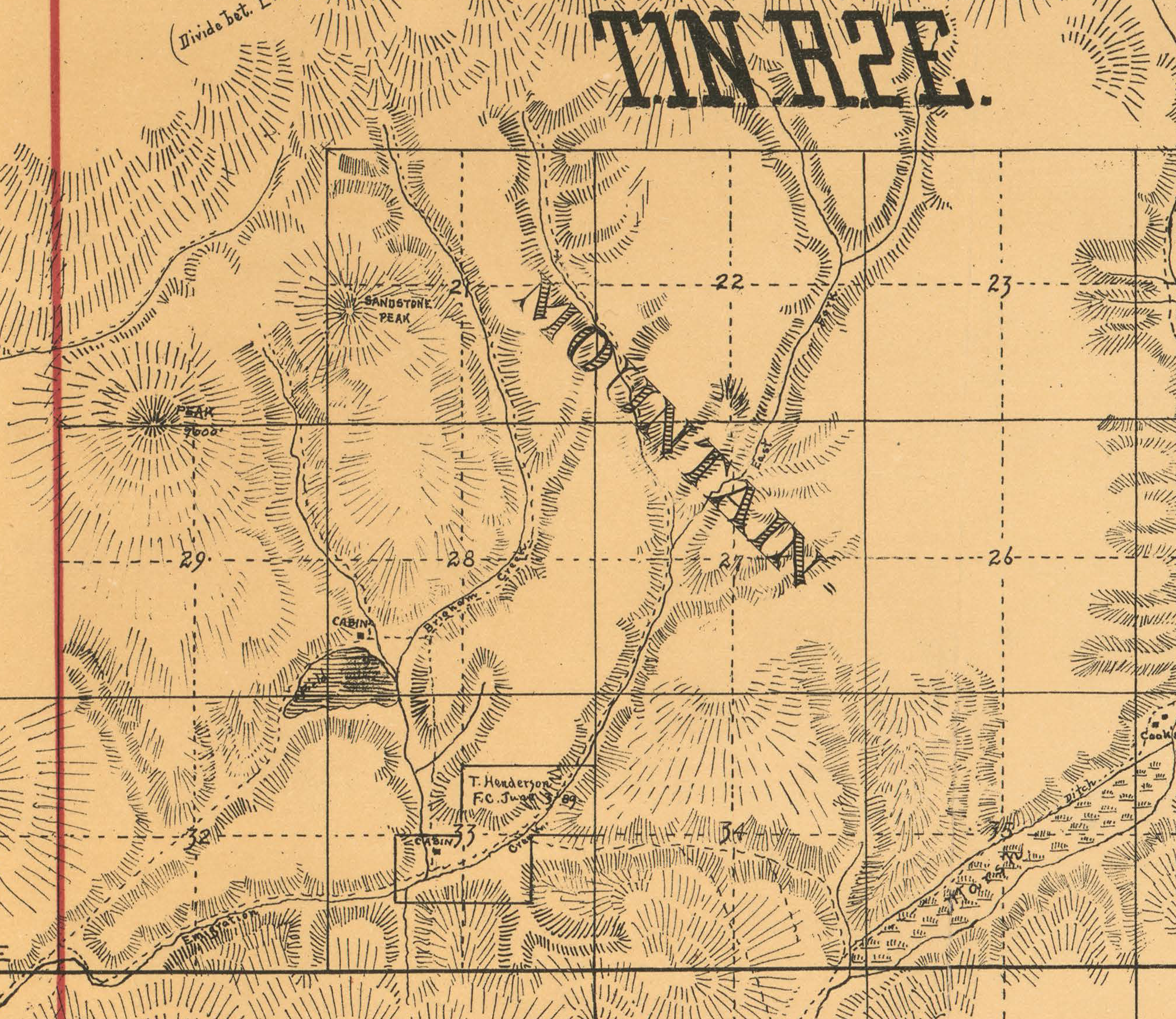
The first recorded map depicting Old Quarry Road and Hendricks Canyon Trail was the original Surveyor General’s Office plat maps from 1882 and 1891. The surveyor, Ferdinand Dickert, describes a “road to Stone Quarry” located 9.60 chains north of the south section border of sections 28 & 29. Dickert provides several more notes with measurements matching up to the present-day location of Pioneer Fork Road all the way to Emigration Canyon Road.
Dickert also describes a “Wagon road N.E. & S.W.” crossing sections 28 and 29 that connects to the Old Quarry Road in Brigham Fork. This same road is later described in Dickert’s notes as an “old road bears N to S” one-half chain East from Freeze Creek crossing sections 20 and 29.
1882 Cadastral Survey Plat Map of T1N R2E SLB&M

The Right-of-Way is depicted in the 1882 and 1891 GLO maps with access to the Subject Parcel from Emigration Canyon Road via Old Quarry Road and Hendricks Canyon Trail.

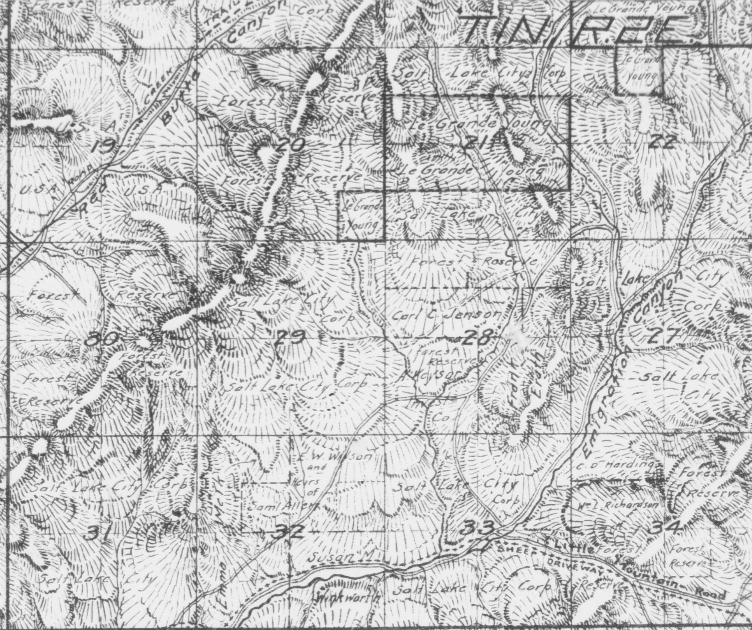
1890 Collier & Cleaveland Lith. Co. Map of Salt Lake County

The Right-of-Way is also depicted in the 1890 Map of Salt Lake County prepared by Collier & Cleveland Lith. Co., of Denver, Colorado and recorded with the United States Library of Congress (source|image). The map of T.1N. R.2E. depicts Hendricks Canyon Trail branching off the Old Quarry Road in Section 28 over Freeze Creek Trail as it exists today bearing north along Freeze Creek through the 40-acre parcel between Sandstone Peak and Peak 7600’ (Pear Peak). Old Quarry Road continues into Brigham Fork and turns north-northwest running through Section 21.


Map of Salt Lake County, Utah by Browne and Brooks, Engineers,
Part 2 of 6 – 01 August 1908
The Right-of-Way is depicted in the Salt Lake County Map by Browne and Brooks, Engineers, Part 2 of 6 from August 1, 1908 compiled from actual surveys and official records in the offices of the U.S. Surgeon Generals for Utah, County Surveyor, County Recorder, U.S. Forest Service, County Water Commissioner and Salt Lake City Engineer, etc, and from private surveys by railroad, power, mining, and real estate companies by Browne & Brooks, Civil and Mining Engineers of Salt Lake City, Utah (source|image). This map depicts the Right-of-Way along the same route as the 1882 map but differentiates the quality of road with two solid parallel lines for the Old Quarry Road and two segmented parallel lines for Hendricks Canyon Trail and a new segment connecting Old Quarry Road to Pinecrest Canyon Road.

Sheet No. 25A, Salt Lake County Surveyor’s Office, circa 1933
The Right-of-Way is depicted in Sheet No. 25A, Salt Lake County Surveyor’s Office, circa 1933 (image), around the time of the Emigration Canyon Road survey. The Old Quarry Road is depicted on this map over the same route as the 1908 county map but Hendricks Canyon Trail is not shown despite being depicted on previous maps and visible in all aerial imagery from 1940 onward.
The Right-of-Way is visible in the Soil Conservation Service (SCS) 1940 COH East Salt Lake Conservation District, Utah Project Aerial Index, Sheet 1, aerial photograph Roll Number 1, Photo Number 98, Publication ID: COH, AIS- 22385, USDA 8920, Utah Geological Survey Resource ID: 22803 dated August 26, 1940 (source|image). The Right-of-Way is clearly visible from Emigration Canyon Road all the way to the Subject Property following the same route described in the 1881 survey notes and depicted on the 1882 cadastral map nearly 60 years earlier. A second trail is visible branching off Hendricks Canyon Trail at the location of the present-day Twin Creek Circle cul-de-sac and running north in Section 29 for approximately a quarter-mile until reconnecting to the historical route north of the quarter corner after it crosses back from Section 28. This mechanically graded branch (referred to herein as the “Jeep Trail”) is visible in all subsequent imagery in its present-day location in a condition suitable for public use.
The Right-of-Way is visible in the United States Army Map Series (AMS) Corps of Engineers 1953 (Western United States High Altitude) Project Aerial Index, Project 121, Area AL, Sheet NK-12-7, Roll Number 18, Photo Number 3393, Publication ID: AMS_121-18-3393, Utah Geological Survey Resource ID: 48263 dated August 12, 1953 (source|image). The Right-of-Way is visible in the same location as the 1940 imagery, but the poor quality makes identifying the Hendricks Canyon Trail route through Section 29 difficult.
Base Map of T1N R2E, Salt Lake County Surveyor & Engineer, 1954, rev. January 1, 1957
The Right-of-Way is depicted on a Salt Lake County Map of T1N – R2E & R3E, Sheet 5 of 18 Sheets, prepared by the Office of Salt Lake County Surveyor & Engineer, 1954, revised January 1957 (image). Old Quarry Road is shown as a primitive road where it leaves Emigration Canyon Road through the S 1/2 of Section 32, then terminating where Private Parcels 3, 4, and 5 transferred to the Bertagnole family in 1950 a few years prior to creation of the map. The remainder of the Right-of-Way is not depicted on the map despite being clearly visible in the same condition as the depicted portion in prior aerial imagery from 1940 and 1953 as well as in subsequent imagery from 1963 onward after the map was created.
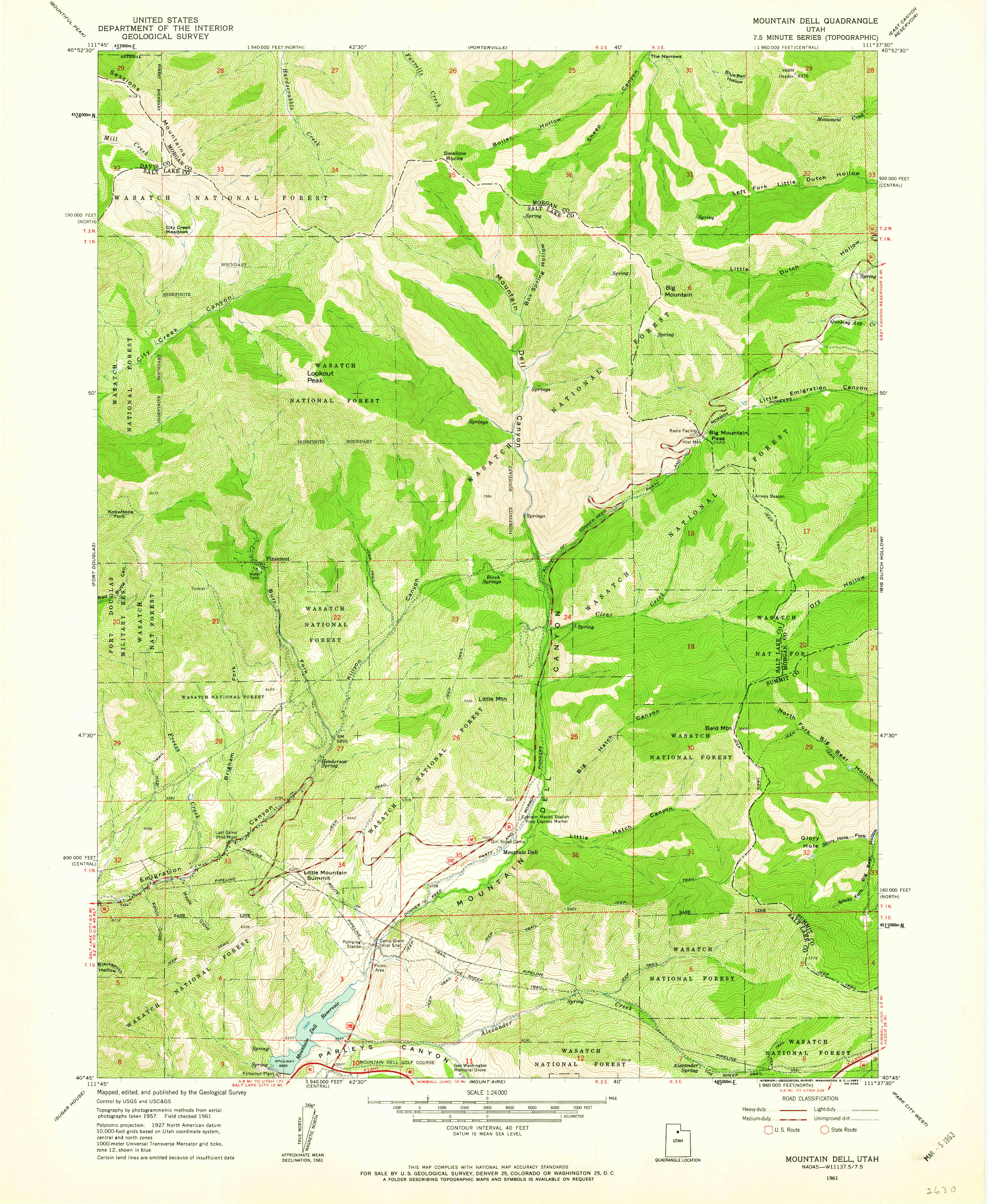
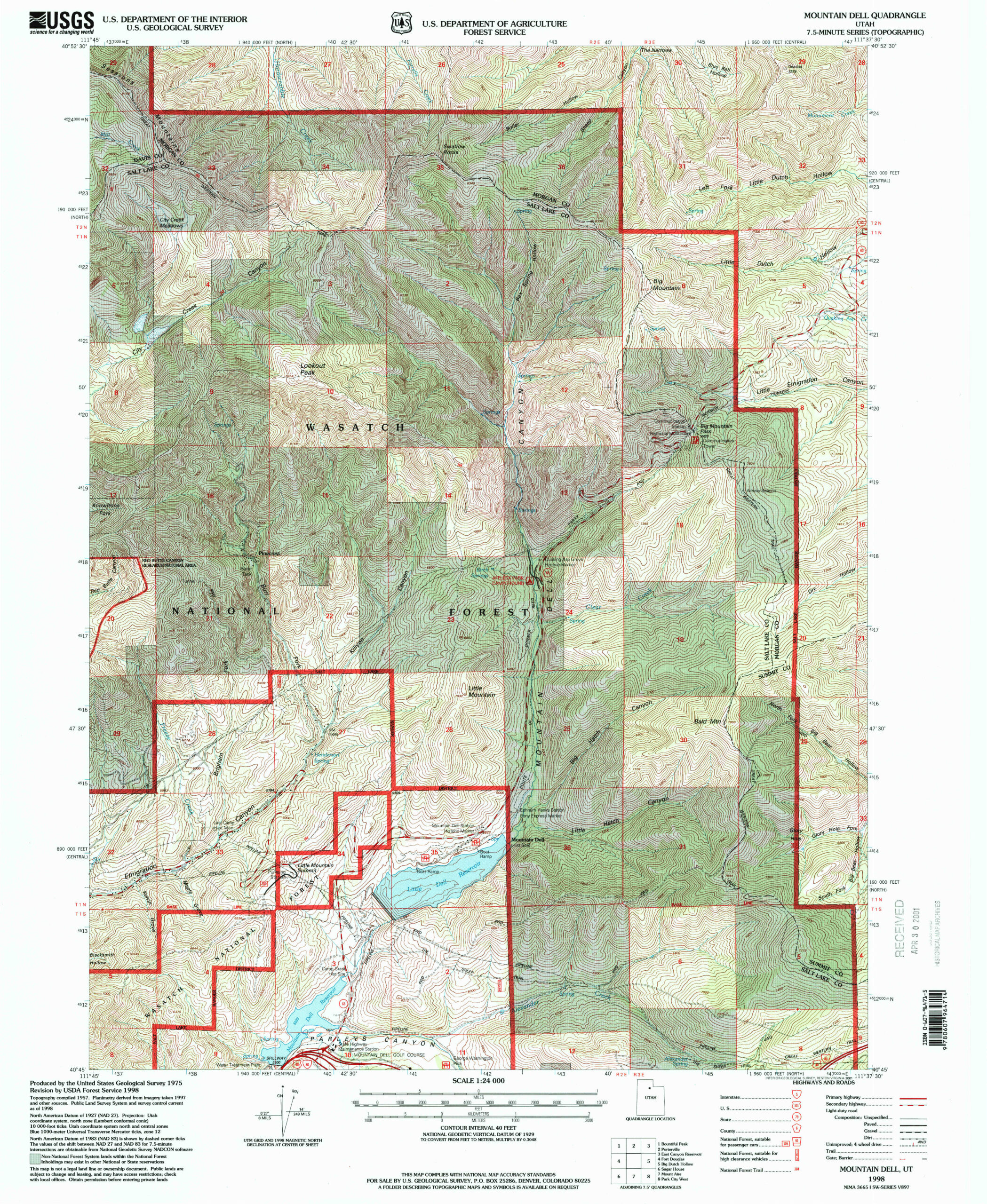
1961 USGS Mountain Dell, Utah Quadrangle Map

The 1961 USGS Mountain Dell, Utah Quadrangle Map (source|image) depicts the Old Quarry Road with a parallel segmented route for an ‘unimproved road.’ Hendricks Canyon Trail is depicted with a single segmented route labeled ‘JEEP TRAIL’ following the historical path crossing into Section 28 south of the quarter section marker and shortly returning into Section 29 north of the same marker. The Right-of-Way is shown providing access to the Subject Property over the same route through sections 32, 29 and 28 as on all previous maps.

Aerial Imagery and Other Evidence
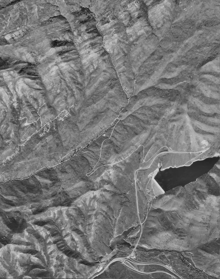
The Right-of-Way is visible in the United States Forest Service (USFS) 1963 ELK (Wasatch-Cache National Forest, Utah) Project Aerial Index, aerial photograph Roll Number 3, Photo Number 83, Publication ID: ELK_3-83, Utah Geological Survey Resource ID: 70607 dated June 25, 1963 (source|image). The Right-of-Way is clearly visible from Section 31 all the way to the Subject Property following the same route described in the 1881 survey notes and depicted on the 1882 cadastral map over 80 years earlier.
The Right-of-Way is visible in the United States Geological Survey (USGS) 1977 Mountain Dell Digital Orthophoto Quadrangle (DOQ) q1221 dated June 28, 1977 (image). The Right-of-Way is visible in the same location as all previous maps and imagery, but the vegetation growth along the Hendricks Canyon Trail makes identifying the route through Section 29 difficult.
The Right-of-Way is visible in the United States Fores Service (USFS) 1983 Aerial Photographs EC 406-409 dated May 29, 1983 (source|image). Old Quarry Road is visible from Emigration Canyon Road through Sections 31 and 32, but the aerial photographs do not capture the Right-of-Way as it crosses Sections 29 and 28. The Old Quarry Road appears to be an improved dirt road at this time with unrecorded trails branching off to the north. No development is shown occurring on the Private Parcels at this time.
The Right-of-Way is visible in the United States Forest Service 1985 Salt Lake County Project Aerial Photograph 21-3 dated August 6, 1985 (source|image). The Old Quarry Road is visible from the west border of Section 32 through Section 29 where it becomes noticeably more overgrown in Sections 28 and 21. Hendricks Canyon Trail is clearly visible over Section 28 and over portions of Section 29 through the thick vegetation present. No development is shown occurring on the Private parcels at this time.
The Right-of-Way is visible in the United States Geological Survey (USGS) 1987 National High Altitude Photography (NHAP), Color Infrared (source|image), Entity ID: NP0NAPP000304181, dated July 23, 1987. Old Quarry Road is visible from Emigration Canyon Road through Sections 31, 32, 29, and 28 into Brigham Fork. Hendricks Canyon Trail is clearly visible in the aerial imagery leaving the Old Quarry Road and crossing into Section 28 where it is obscured by vegetation. The Jeep Trail is also visible leading into Section 28. Very few homes exist along the Right-of-Way at this time but numerous off road trails are present across the Freeze Creek area.
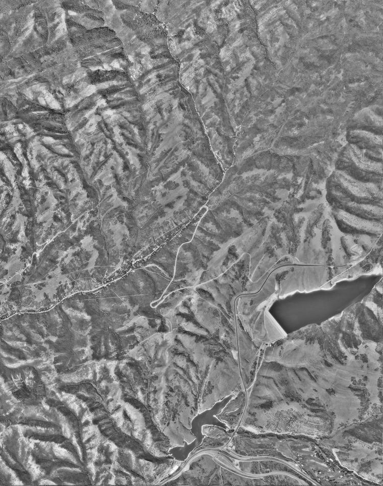
The Right-of-Way is visible in the United States Geological Survey (USGS) 1993 Mountain Dell Digital Orthophoto Quadrangle (DOQ) q1221, source system ID: N 5921 219, dated September 8, 1993 (source|image). The Right-of-Way is visible from Section 32 to the Subject Property. Pioneer Fork Road is now present over a portion of the Old Quarry Road up to Section 29 and new houses are being built in Section 32. Hendricks Canyon Trail is visible from Pioneer Fork Road, but vegetation growth makes it difficult to identify the portion of the Right-of-Way over Section 29.
The Right-of-Way is visible in the United States Geological Survey (USGS) 1997 Mountain Dell Digital Orthophoto Quadrangle (DOQ) q1221, entity ID: DI00000001054303, source system ID: NAPP 10102 260, dated October 4, 1997 (source|image). Pioneer Fork Road is paved over the Old Quarry Road into Section 28 with multiple new streets providing frontage to dozens of recently built houses. Emigration Estates Road appears improved but no houses exist along it. The unpaved segment of the Right-of-Way over Section 29 is visible along Freeze Creek to the Subject Property.
The Right-of-Way is depicted in the United States Geological Survey (USGS) 1998 Mountain Dell Quadrangle (source|image) showing a trail over Section 29. The 1998 revision of the USGS Mountain Dell, Utah Quadrangle Map depicts Pioneer Fork Road, Emigration Estates Road, and North Twin Creek Circle as light-duty roads with unknown composition. The Jeep Trail is again depicted as a single segmented route, the same trail markings on 1961 Quadrangle, but is not labeled. The route of the Right-of-Way remains approximately the same as it was in 1881.
The Right-of-Way is included on the Emigration Canyon Township Recreational Trails and Trail Access Plan (page 55 at 104/108) in the 1999 Emigration Canyon General Plan (source|image) according to Salt Lake County Public Works Department. The General Plan describes the situation of Freeze Creek Trail Access Point #8 depicted on the map as follows: “This access point begins at the end of Margarethe Lane off of Emigration Canyon Road. The trailheads up the hillside along the Freeze Creek drainage through private land, then connects up with other trails, which lead into the National Forest. This is a very popular area for recreational activities even though it is private land. In addition, the Emigration Oaks subdivision is continually being added to and trail access is being lost. It is very important to provide access through the subdivision to the National Forest for the general public as well as the local residents.” Access Point #9 is located at the cul-de-sac of Twin Creek Circle where the paved portion of the Right-of-Way changes to an improved trail. Comments for Freeze Creek Trail Access Point #9 state, “This access point is similar to #8. It is a trail leaving from the same road and in the Freeze Creek drainage. It accesses the National Forest and one of the most beautiful areas in Emigration Canyon. This access point is also threatened from the expansion of Emigration Oaks. It is crucial to acquire trail access at this point.”
The Right-of-Way is visible in in the United States Department of Agriculture, Forest Service (USDA-F) 2001, Project 614190, Roll 1801, Photo 89, Publication ID: 614190_1801-89, Utah Geological Survey Resource ID: 96778 dated July 16, 2001 (image). Emigration Estates Road and Twin Creek Circle are visible as a paved road with only a couple of houses present at the intersection with Pioneer Fork Road. All of Hendricks Canyon Trail is clearly visible across Section 29 and part of Section 28 to the Subject Property.
The Right-of-Way is visible in the United States Geological Survey (USGS) 2003 High Resolution Orthoimagery, Entity ID:1304607_12TVL365150, dated September 14, 2003 (source|image). The Right-of-Way is visible over parts of Section 28, 29, and 32. A few houses are now present along Emigration Estates Road with Twin Creek Road ending in a cul du sac. Hendricks Canyon Trail is visible from the cul du sac with vegetation growth obscuring portions of the Right-of-Way over Section 29.
The Right-of-Way is visible in the United States Geological Survey (USGS) 2006 High Resolution Orthoimagery, Entity ID: 772472_12TVL360120 (source|image) and Entity ID: 772473_12TVL360160 (source) dated February 02, 2006. The Right-of-Way is visible over parts of Section 28, 29, and 32. A house has been constructed on the cul du sac over the Jeep Trail but Hendricks Canyon Trail remains accessible to Section 28 and visible with vegetation growth obscuring portions of the Right-of-Way over Section 29.
Hendricks Canyon Trail is included on Map 3 – Existing Trails (page 8 at 13/39) in the 2007 Emigration Canyon Trails Master Plan (source|image) according to Salt Lake City Public Utilities – GIS Division Database. This data was likely obtained through Tom Ward, Salt Lake City Public Utilities Watershed Manager and member of the Advisory Committee. Appendix to the 2007 Trails Master Plan contains a comment stating, “We need to secure some of the local trails not illustrated on the three alternatives, including Freeze Creek and other trails that are commonly used today.”
The Right-of-Way is visible in the United States Geological Survey (USGS) 2009 High Resolution Orthoimagery, Entity ID: 1487149_12TVL360140 (source|image) and Entity ID: 1486293_12TVL360160 (source) dated April 21, 2009. The Right-of-Way is visible over parts of Section 28, 29, and 32. A new house has been constructed along Twin Creek Road. Hendricks Canyon Trail is clearly visible leading into Section 28 with vegetation growth obscuring portions of the Right-of-Way over Section 29.
The Right-of-Way is visible in the United States Geological Survey (USGS) 2012 High Resolution Orthoimagery, Entity ID: 2657956_12TVL360140 (source|image) and 2657012_12TVL360160 (source) dated March 08, 2012. The Right-of-Way is visible over parts of Section 28, 29, and 32. Hendricks Canyon Trail is clearly visible leading into Section 28 with vegetation growth obscuring portions of the Right-of-Way over Section 29.
Recent Images of Freeze Creek Jeep Trail
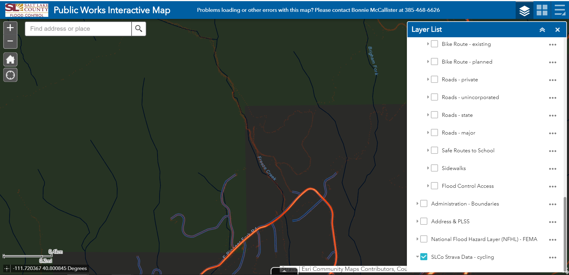
The usage of the Right-of-Way is visible in the Salt Lake County Public Works Strava data accessed on June 6, 2020 (image). The GIS data indicates usage of the Right-of-Way as of 2020 has largely shifted to Freeze Creek Trail and to EID’s Upper Freeze Creek Well access road leaving Emigration Estates Road.
Photographs of the Jeep Trail in 2020 (images) and Wagon Trail in 2022 (images) show the Right-of-Way exists in a condition suitable for public use. Hendricks Canyon Trail is clearly visible in the photographs where it leaves Twin Creek Circle. The trail remains clear of vegetation and a distinct grade is present from previous mechanical maintenance.