The Treaty of Guadalupe Hidalgo, signed February 2, 1848, made all land in the Utah Territory part of the public domain in the possession of the United States government with clear title.
The Subject Property was the first private parcel conveyed in Township 1 North, Range 2 East of the Salt Lake Meridian. Lloyd G Johns filed homestead application 5656 on May 31, 1882 (source|image) which was deeded through Homestead Entry patent 1965 on July 20, 1888 (source|image) by the United States of America under authority of the 1862 Homestead Act according to the official plat of the survey of the said land returned to the General Land Office (GLO) by the Surveyor General.
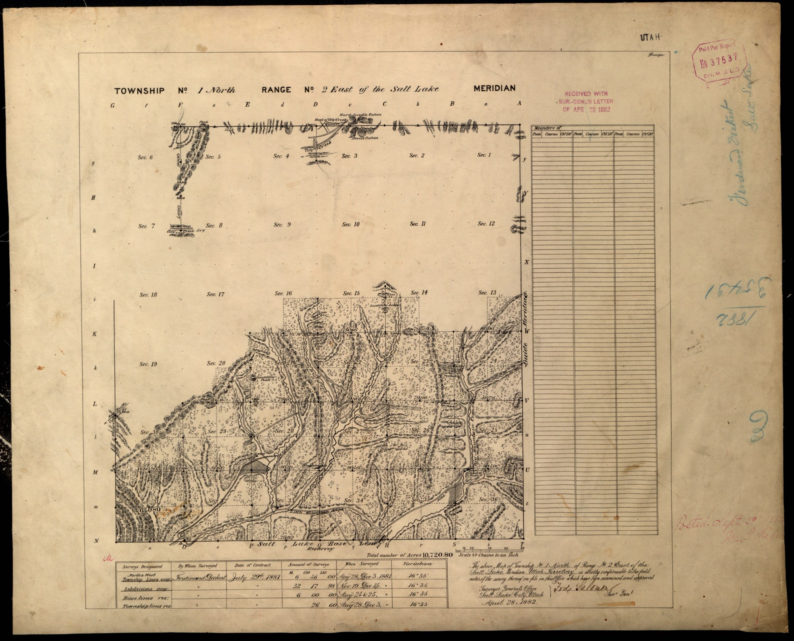
The referenced GLO plat is the 1882 Cadastral Survey Map of T.1N. R.2E. SLBM (source|image) conforming to the 1881 Survey Field Notes in Book A-185 (source|image) examined and approved by Frederick Salomon, Surveyor General of Salt Lake City. The Right-of-Way is depicted as a public highway on the 1882 GLO Plat according to U.S. Deputy Surveyor Ferdinand Dickert field notes from December 1881 referencing an “old road,” “wagon road,” and “road to Stone Quarry.”
Old Quary Road is depicted running from Emigration Canyon Road in Section 31 through Sections 32, 29, 28, and 21 over a portion of present-day Pioneer Fork Road. The first segment of Old Quarry Road recorded on December 14, 1881, “Chains from the cor[ner]. to secs 31 and 32” notes “Bottom of Brigham Gulch Drains S.W. road bears N.E. & S.W.” at 13.00 chains (p. 83). Another segment of Old Quarry Road is recorded on December 14, 1881, “Chains east on a random line bet[ween] sects 29 and 32” where “road bears S.W. & N.E” at 72.30 chains (p. 85). The survey of “Chains North bet[ween]. sec. 28 and 29” recorded on December 11, 1881 describes Old Quarry Road as “Wagon road N.E. & S.W.” 9.60 chains north of the south section border (p. 75).
Hendricks Canyon Trail is noted at 36.00 chains north of the south section line between Sections 28 and 29 as “Wagon road N.E. & S.W.” and again as “road bears NW and S. East” at 46.00 chains north along a “Dry Creek 3 ft. 4 links wide 1 ft. deep Drains SE” noted 43.00 chains north (p. 75). Hendricks Canyon Trail continued north and is recorded in “Chains east on a random line bet[ween]. Sec[tion]. 20 and 29” from December 15, 1881 as “old road bears N to S.” at 67.50 chains along side “Creek 10 in. 1 link wide 2 in. deep runs S.” at 67.00 chains (p. 91).
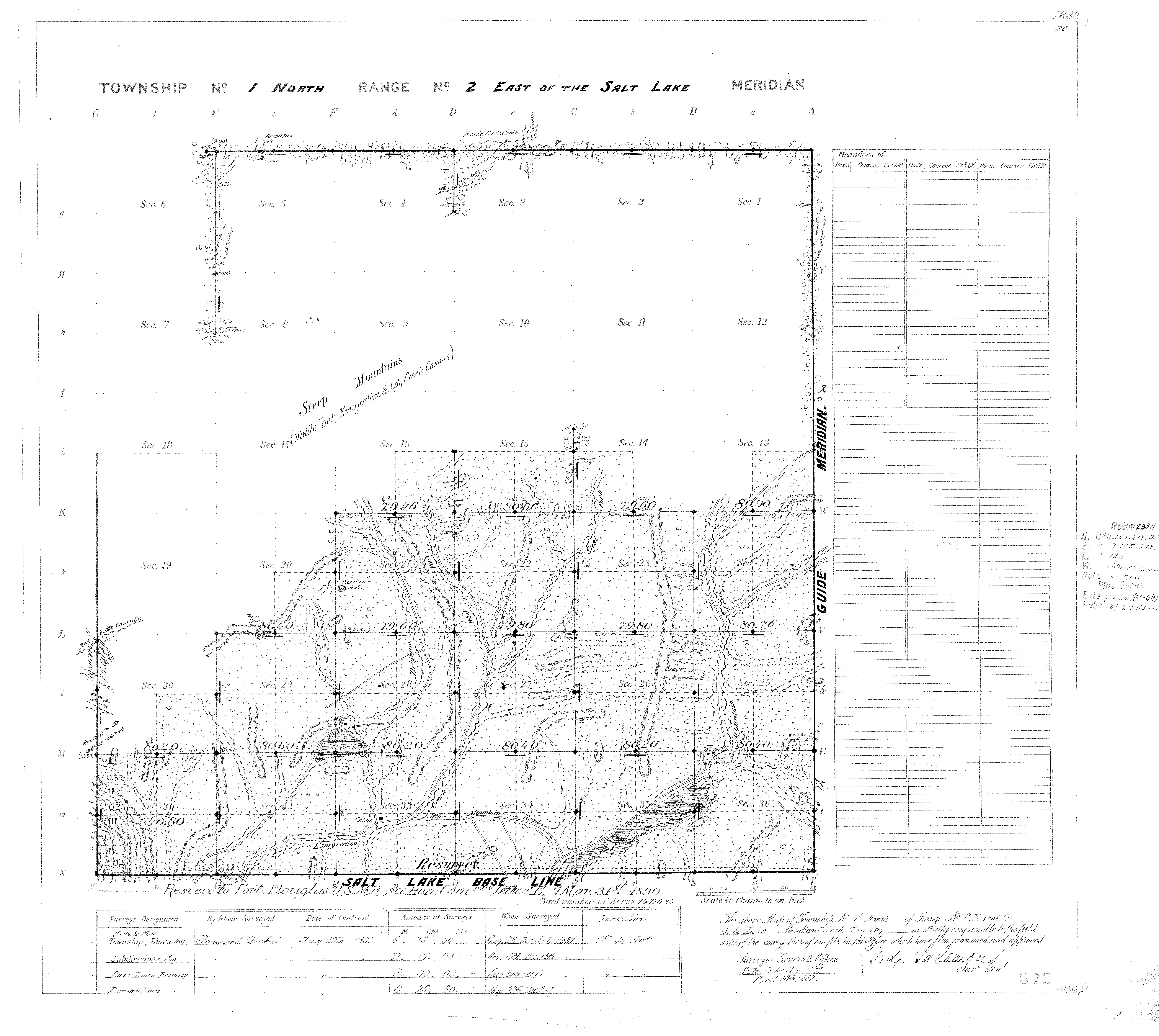
The Right-of-Way was noted in the 1886 Fields Notes of Subdivisions T.1N. R.2E. (source|image) resurveyed by US. Deputy Surveyor Otto E. Salomon and depicted in the 1891 Cadastral Survey Map of T.1N. R.2E. SLBM (source|image) conforming to the 1886 Survey Field Notes examined and approved by Ellsworth Daggertt, Surveyor General of Salt Lake City. On August 3, 1886, Salomon’s notes for the “Eastern random resurvey line bet[ween] Sec 20 & 29” states “Road bears N & S” at 12.90 chains and “Creek 2 links wide 2” deep Runs S” at 13.40 chains (Book A-218, p. 346). The 1882 and 1891 Cadastral Plat Maps of T.1N. R.2E. both depict a wagon road crossing through the Subject Property and continuing into the NE1/4 of the SE1/4 of Section 20 approaching the shoulder of a point named Sandstone Peak.

The conveyance of Llyod’s patent recorded with the Salt Lake County Recorder’s Office[1] (source|image) referencing the 1882 and 1891 GLO plats and respective field notes depicting the Right-of-Way served to impart notice to all persons of the contents thereof, including subsequent purchasers of the Private Parcels also recorded in the same office according to the same plats.[2]
The Utah Territorial Legislature passed an act effective March 13, 1884[3] requiring the Surveyor General to “distribute all books, records, plats and papers of surveys made within the counties in the Territory in his possession and appertaining to his office, to the county surveyors, the portions relating to their respective counties, and all other property belonging to said office to the county surveyor of Salt Lake county and when so distributed to be the property of said counties.” County recorders were also required to keep an “Index to Recorded Maps, Plats and Subdivisions, such index to be made by description of land mapped, or subdivided by range, township, section, quarter section, or other legal subdivision.”[4]
Statutory dedication of roads by plat was first established by the 1890 Laws of the Territory of Utah, effective March 13, 1890[5] authorizing the owner of any land to lay out and plat it into lots, streets, alleys, and public places, and providing for dedication of the public places. The Supreme Court of Utah in Sowadzki v. Salt Lake County, 36 Utah 127, 104 p. 117 (1909) established this act applied equally to land outside, as to that within, incorporated cities and towns. Section 4 (Laws 1890, p. 77, c. 50) provided that a plat of land when made, acknowledged, filed, and recorded shall be a dedication of all the streets and public places shown thereon, the dedication is complete without a formal acceptance by the public authorities.
Executive Order 438-W-D-1890 (source|image) was initiated by Secretary of War Redfield Proctor in a memo to President of the United States of America Benjamin Harrison dated March 3, 1890, requesting the reservation of the “E1/2 Sect. 20 Tp. 1 N. R. 2 E., Salt Lake Meridian, with the exception of the SE 1-4 of the SE 1-4 Sec. 20 Tp. 1 N. R. 2 E.” according to “the plat of the proposed addition [] herewith enclosed.” President Benjamin Harrison approved Executive Order 438-W-D-1890 on March 18, 1890, stating “The within request is approved, and the addition to the Fort Douglas Reservation is made and proclaimed accordingly. The Secretary of the Interior will cause the same to be noted in the General Land Office.”

The General Land Office annotated the 1882 plat map (source|image) with the notation “Reserved to Fort Douglas U.S.M.B., see Hon. Com. Letter E March 31, 1890” and depicted the boundaries of the Subject Property with frontage upon the Right-of-Way. From this time until at least November 1891, all land under which the Right-of-Way ran was in the public domain from which the federal government conveyed “according to the official plat of the survey of the said land returned to the General Land Office by the Surveyor General.”
Parcel 6 remained public land until purchased by Arthur Meads on November 9, 1891 through Cash Entry patent 3662 under authority of the 1841 Preemption Act. (source|image)
Parcel 1 remained public land until deeded to John P. Wretburg on August 21, 1896 through Homestead Entry patent 5449 (source|image) under authority of the 1862 Homestead Act.
Parcel 7 remained public land until deeded to Carl G. Jensen on January 12, 1897 through Homestead Entry patent 5552 (source|image) under authority of the 1862 Homestead Act.
Parcel 2, Parcel 3, and Parcel 4 remained public land until deeded to the State of Utah in Section 6 of an Enabling Act approved July 16, 1894 by the of the United States Congress (source|image) and later transferred to the private ownership of the Sam Allen’s legal heirs on June 11, 1907.[6]
Parcel 5 and Parcel 8 remained public land until February 27, 1897 when Railroad Entry patent 30[7] (source|image) was deeded to Union Pacific Railroad Company by the United States of America under authority of the 1862 Pacific Railroad Act.

All eight of the Private Parcels were conveyed according to the 1882 GLO plat with the 1890 annotations by Executive Order of the President of the United States depicting the Subject Parcel boundaries and the Right-of-Way providing access to it over the public domain. The conveyance of the Private Parcels recorded with the Salt Lake County Recorder’s Office according to the official GLO plat which depicted the Right-of-Way served to impart notice to all persons of the contents thereof, and subsequent purchasers of the Private Parcels that purchased with notice.[8]
There is no evidence in the public record that the Salt Lake County Recorder recorded the GLO plats sent by the Surveyor General in accordance with Territorial Law. However, limits on the parol evidence rule provide that if the deed refers to another document, like a plat, that document is not extrinsic evidence but is considered part of the conveyance itself, just as if it were attached to the deed. Reference to a survey completed prior to the conveyance is considered to be a reference to another document and the entire survey then becomes a part of the description. This includes not only the plat or map of the survey, but all evidence thereof, including the field notes.[9]
The patent deed[10] conveying[11] the Subject Parcel and Private Parcels were also perfected by 1898 state law. These curative statutes are similar to those in Idaho sufficient to established plats filed only with the General Land Office were valid despite not being recorded with the county recorder office.[12] The Utah Code Annotated 1953 references “sufficiency as common-law dedication of incomplete statutory dedication, or ineffectual attempt to make statutory dedication.”[13]
Decisions from other Jurisdictions also cited in the Utah Code Annotated, 1953 include:
An act passed by the legislature validating plats impressed upon all plats, theretofore filed, a dedication to the public of the streets and alleys, outlined in such plats, with the same force and effect as though a dedication had originally been placed upon such plats. Powell v. McKelvey, 56 Idaho 291, 53 P. 2d 626.
Where there is plat on which owner lays off lots, blocks, and streets, and adopts such plat by reference in selling, this amounts to irrevocable dedication of streets. Wolfe v. Kemler, 228 Iowa 733, 293 N. W. 322.
A plat not dealing with an incorporated town may work a common-law dedication of streets therein provided for. Iowa Loan & Trust Co. v. Board of Supra. Polk County, 187 Iowa 160, 174 N. W. 97, 5 A. L. R. 1532.
SUWA[14], the leading Utah decision interpreting R.S. 2477, mentions “principles” of state law, not statutes, and judicial precedent is as much state law as a statute is. The Tenth Circuit found “Dedication by the landowner could be manifested by express statement or presumed from conduct, usually by allowing the public ‘the uninterrupted use and enjoyment of their privilege’ over a specified period of time…In the years after its enactment, R.S. 2477 was uniformly interpreted by the courts as an express dedication of the right of way by the landowner, the United States Congress. Courts have long interpreted R.S. 2477 as an express dedication of a right of way by the landowner, the United States Congress, acceptance of which by the public results from use by those for whom it was necessary or convenient.[15] Many R.S. 2477 decisions make no mention of statutes when analyzing acceptance.
The Tenth Circuit held that validation of R.S. 2477 claims is a matter of federal law, but federal law ‘borrows’ from long-established common law and principles of state law to the extent that they are useful in effectuating congressional intent.
[The fundamental basis of implied dedication] was well expressed in an early United States Supreme Court case, Cincinnati v. White (31 u.S. 431, 1832), by the statement: “There is no particular form necessary to a dedication of land to public use. All that is required is the assent of the owner of the land, and the fact of its being used for the purposes intended.” […] Application of the doctrine usually occurs where there has been a map of a subdivision or town prepared and lots then sold with reference to the map.
The United States as a land owner made an offer to dedicate unappropriated land for highways. The easement for its use as a public highway was created exactly as those of which the dedicator was an individual land owner.
Utah Code 72-5-301 (1)(c) allows for acceptance by “any other act consistent with state or federal law indicating acceptance of a right-of-way”. The Supreme Court of Utah in Sowadzki v. Salt Lake County, 36 Utah 127, 104 p. 117 (1909) established:
1. Dedication — Platting Land Outside Municipality. Act March 13, 1890 (Laws 1890, p. 76, c. 60), authorizing the owner of any land to lay out and plat it into lots, streets, alleys, and public places, and providing for dedication of the public places, applies as well to land outside, as to that within, incorporated cities and towns.
2. Dedication — Necessity of [sic] Acceptance. Under Act March 13, 1890 (Laws 1890, p. 77, c. 50), section 4, providing that a plat of land when made, acknowledged, filed, and recorded shall be a dedication of all the streets and public places shown thereon, the dedication is complete without a formal acceptance by the public authorities.
This case stands for the idea that where land is surveyed, platted, and recorded pursuant to provisions of statute, the dedication of roads in such a plat is an irrevocable dedication to the public, and a sale or conveyance made in reference to the plat completes the dedication without any formal acceptance by public authorities. Thus, when the federal government issued a homestead patent pursuant to a map or survey notes depicting a road, that road is deemed to have been dedicated to the public by the federal government (Farrell, 138 Idaho at 385, 64 P.3d at 311). The Farrell case established Homestead patents prior to the enactment of state statute dedicate a road under common law. “If the road creation method is a common law dedication based on the fact that the road is depicted or described on the survey accompanying a homestead or mining claim patent, then it is necessary to show only that the survey predated the entry date. In the context of homesteads, the date on which land is segregated from the public domain is the date of “entry.” Entry refers to the date of “application to acquire title to public lands.” (Meyer, 2021: 35-36, 45-46).
In Farrell, the federal government as owner created an offer to dedicate by recording a plat in the form of a survey map and notes while the grant of a homestead patent pursuant to the map constituted a valid acceptance of a common law dedication:
“The second transaction [homestead patents granted by the federal government], however, is a valid common law dedication of the road. The federal government was the owner of the land, and it filed and recorded a valid plat. That is sufficient under Worley to show intent on the part of the owner to dedicate public areas of the plat. The district court decision on this issue cited Nesbitt v. Demasters, 44 Idaho 143, 255 P. 408 (1927), for the proposition that a valid common law dedication offer and description must be clear and certain. That the road was clearly marked and labeled on the plat and patent is sufficient to create an offer to dedicate a public road. In a case where the roads are not yet built and the plat is part of a subdivision plan, it makes more sense to require a metes and bounds type of description, but where, as here, there is already a road in existence and labeled and marked on the map, the offer requirement is met.
Furthermore, the grant of homestead patents constitutes a valid acceptance of a common law dedication. In Worley this Court reversed a trial judge for incorrectly looking to the intentions of the purchaser to determine if the purchaser intended to accept the government’s implied offer of dedication. 116 Idaho at 225, 775 P.2d at 117. In this case the fact that a plat was validly filed and patents sold referencing the plat and the road constitutes common law dedication. In Smylie v. Pearsall, the court stated that “[w]hen an owner of land plats the land, files the plat for record, and sells lots by reference to the recorded plat, a dedication of public areas indicated by the plat is accomplished. This dedication is irrevocable except by statutory process.” 93 Idaho 188, 191, 457 P.2d 427, 430 (1969). The patents were granted to the homesteaders with reference to the valid plats and with the Indian Creek Road marked and labeled. There was a common law dedication of the road independent of the intent of the homesteaders.”
And after being thus set apart for public use, and enjoyed as such, and private and individual rights acquired with reference to it, the law considers it in the nature of an estoppel in pais, which precludes the original owner from revoking such dedication. It is a violation of good faith to the public, and to those who have acquired private property with a view to the enjoyment of the use thus publicly granted.
In Schettler v. Lynch, 23 Utah 305, 64 Pac. 955 (1901), the Supreme Court of Utah held:
Dedication of land for highway may be either express, as where owner manifests his purpose by grant evidenced by writing, or implied, as where acts and conduct of owner clearly manifest his intention to devote land to public use. Dedication of land as highway may be inferred from public’s long continued use of it as such with knowledge of, and without objection from, owner. Implied dedication of land for highway is found on doctrine of equitable estoppel. Where land is dedicated by owner as highway and is accepted by public as such, all subsequent grantees of abutting lands are bound by dedication.
This case is later cited by the Supreme Court of Utah in Morris v. Blunt et al., 49 Utah 243 (1916):
A dedication rests primarily in the intent of the owner. There must be a concession intentionally made by him, which may be provide by declarations or by acts, or may be inferred from circumstances. No form or ceremony is necessary. It must, however, appear that he knew of the use by the public, and intended to grant the right of way to the public. No formal acceptance by any public officer or agent is necessary, but there must be actual use by the public. City of Cincinnati v. White, 6 Pet. 440, 8 L. Ed. 452; Morgan v. Railroad Co., 96 U.S. 723, 24 L. Ed. 743; Harkness v. Woodmansee, 7 Utah 227, 26 Pac. 291; Whittaker v. Ferguson, 16 Utah 240, 51 Pac. 980; Schettler v. Lynch, 23 Utah 305, 64 Pac. 955; Culmer v. Salt Lake City, 27 Utah 252, 75 Pac. 620; Wilson v. Hull, 7 Utah 90, 24 Pac. 799.
A survey and plat alone are sufficient to establish an offer to dedicate if it is evident from the face of the plat that it was the intention of the proprietor to set apart certain ground for public use.[16] Where subdivision has been platted and sales made with reference to plat, dedication is presumed in regard to all areas which appear to be labeled as public areas, whether or not such areas are specifically dedicated to use of public by appropriate wording; primary concern of courts is to determine intention of subdivider, and if intention of subdivider is inconsistent with presumption and dedication, intention prevails over presumption.[17] Thus, when the federal government issues a homestead patent pursuant to a map or survey notes depicting a road, that road is deemed to have been dedicated to the public by the federal government.[18]
Dedication may be based on a plat depicting the road without any express words of dedication.[19] If further circumstances are required to reinforce the implication of a dedication, they may be found in R.S. 2477 itself. The homesteading of the West occurred against the backdrop of Congress’s express goal of creating a network of roads in the newly settled areas that were fundamental to prove up the land for five years. See discussion in section III at page 7.
DEDICATION BY PLATTING OF R.S. 2477 RIGHT-OF-WAY IN 1888 and 1890: supported by direct evidence
Statutory dedication by platting of the Right-of-Way under the Laws of the Territory of Utah 1890, § 2014, effective March 13, 1890 was fulfilled on March 18, 1890 by Executive Order 438-W-D-1890 of the President of the United States of America instructing the Secretary of the Interior to record the plat of the proposed addition herewith enclosed in the General Land Office. Additionally, a common law dedication occurred in 1888 when the United States, as landowner, offered to dedicate the Right-of-Way to the public by filing a plat showing the road and the offer was accepted by conveyance of the Subject Parel and Private Parcels with reference to the plat.
[1] Salt Lake County Recorder’s Office recorded on December 21, 1888 in Book 2Q, Page 582-583
[2] Revised Statutes of the State of Utah 1898, Title 67, Chapter 4 § 2000
[3] Compiled Laws of the Territory of Utah 1888, Volume I, § 29. s 2.
[4] Compiled Laws of the Territory of Utah 1888, Volume I §145, s.8
[5] Such maps and plats when made, acknowledged, filed and recorded with the county recorder, shall be a dedication of all such avenues, streets, lanes, alleys, commons, or other public places or blocks, and sufficient to vest the fee of such parcels of land as are therein expressed, named, or intended, for public uses for the inhabitants of such town and for the public for the uses therein named or intended. (Laws of the Territory of Utah 1890, § 2014)
[6] Recorded as Entry 224744 in Book 7-E, Page 65-66 on July 12, 1907. (source|image)
[7] Recorded as Entry 109968 in Book 5B, Pages 575-582 on March 16, 1897. (source|image)
[8] Revised Statutes of the State of Utah 1898, Title 67, Chapter 4 § 2000
[9] Boundary Location in Sequence and Simultaneous Conveyances. David W. Pehr (2016). P. 1. (source)
[10] 57-4-4 (R.S. 1898, 2010). Deeds informally executed, etc., recorded prior to Jan. 1, 1898. All instruments of writing that were, previous to the date the Revised Statutes take effect, copied into the books of record of the office of the county recorders of the several counties of this state, shall, after that date, impart to subsequent purchasers and incumbrancers, and to all other persons whomsoever, notice of the contents of all such instruments, so far as and to the extent that the same may be found recorded, copied, or noted in the said books of record, notwithstanding any defect, omission, or informality existing in the execution at the time of acknowledgment, certificate of acknowledgment, recording, or certificate of recording the same; and all such instruments, and the records or authenticated copies of the records thereof shall be admissible in evidence, notwithstanding such defects or omissions; but nothing herein contained shall be construed to affect any right or title acquired prior to that date by subsequent purchasers, grantees, incumbrancers, or assignees. [C.L. § 2622; 1890, pp. 1-2; 1892, pp. 18–19; 1894, p. 59; 1896, p. 344, Laws of the Territory of Utah 1898 § 2010, p. 471]
[11] 57-3-9. (R.S. 1898, 2003) Conveyances prior to January 1, 1898-Recording-Effect. All conveyances of real estate made before January 1, 1898 and acknowledged or proved according to the laws in force at the time of such making and acknowledgment or proof, have the same force as evidence, and may be recorded in the same manner and with the same effect, as conveyances executed and acknowledged in pursuance of this title.
[12] Idaho platting statutes have long required that plats be filed County recorder’s office. In Worley Highway Dist. v. Yacht Club of Coeur d’Alene, Ltd., 116 Idaho 219, 224, 775 P.2d 111, 116 (1989), the plat was filed in the General Land Office in Boise, not with the County. The Court affirmed the trial court’s conclusion that this defect was corrected pursuant to a “curative” statute providing recognizing as valid all plats that “have been made and recorded in pursuance of any law heretofore in force.” Idaho Code § 50-1315
[13] 63 A. L. R. 667
[14] So. Utah Wilderness All. v. Bureau of Land Mgmt. (SUWA), 425 F.3d 735, 740 (10th Cir. 2005).
[15] So. Utah Wilderness v. Bureau of Land Mgmt, Nos. 04-4071 04-4073, (10th Cir. Jan. 6, 2006) citing Murray v. City of Butte, 14 P. 656, 656 (Mont. Terr. 1887); McRose v. Bottyer, 81 Cal. 122, 126 (1889); Street v. Stalnaker, 85 N.W. 47, 48 (Neb. 1901); Wallowa County v. Wade, 72 P. 793, 794 (Ore. 1903); Okanogan County v. Cheetham, 80 P. 262, 264 (W ash. 1905), overruled on other grounds by McAllister v. Okanogan County, 100 P. 146, 148 (Wash. 1909); Nicolas v. Grassle, 267 P. 196, 197 (Colo. 1928); Lindsay Land Live Stock Co. v. Churnos, 285 P. 646, 648 (Utah 1929). See discussion in SUWA “2. The public use standard”
[16] 26 C.J.S. Dedication § 17
[17] 26 C.J.S. Dedication § 22; Dedication 19(5), 41
[18] Farrell v. Bd. of Cty. Comm’rs of Lemhi Cty., 138 Idaho 378, 385, 64 P.3d 304, 311 (2002)
[19] The Court will presume or infer that sales conducted pursuant to plats showing roads are intended to dedicate those roads to the public unless express words or other compelling circumstances point to a different conclusion. Boise City v. Hon, 14 Idaho 272, 280, 94 P. 167, 169 (1908)